 Tour of Japanese shrines and temples
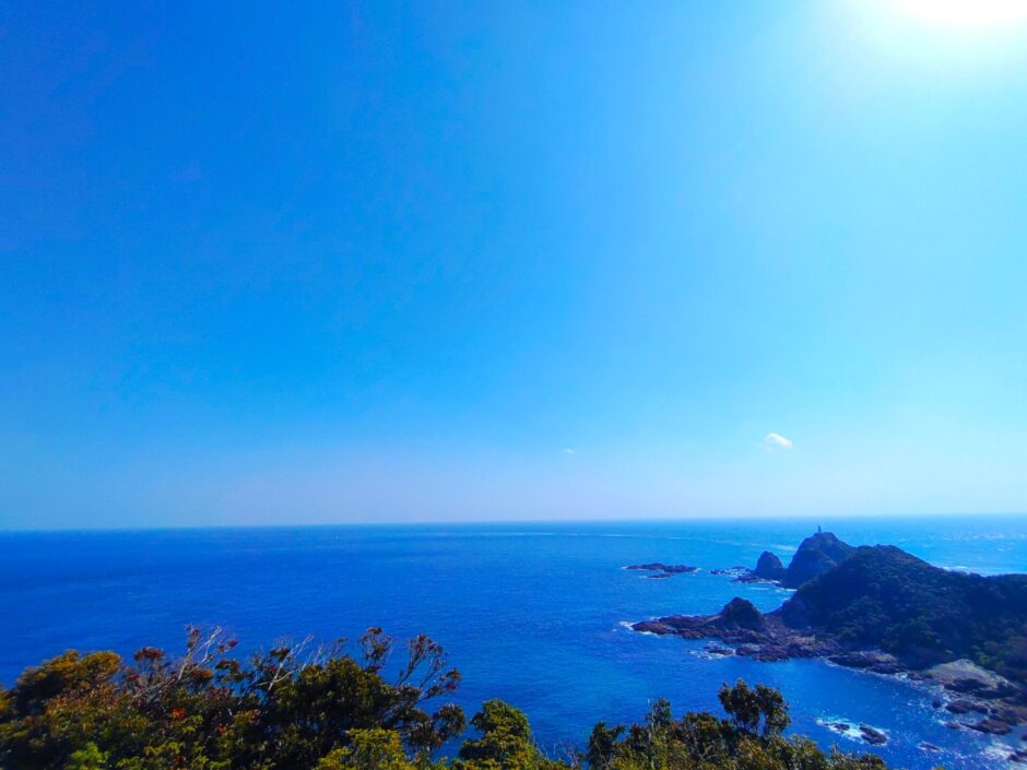

目次
- 【Cape Sata Park summary】
- 【Cape Sata, the southernmost tip of the mainland】
- 【Cape Sata Park Entrance Tunnel】
- 【Cape Sata Park Misaki Shrine】
- 【Sado Point Park Observation Deck】
- 【Cape Sata Park (Misaki Shrine) Nearby attractions】
- 【Cape Sata Park (Misaki Shrine) Access】
- Manager’s Comments
- Cape Sata Park (Misaki Shrine)
【Cape Sata Park summary】
Cape Sata Park is the southernmost cape on the mainland, located on the 31st parallel of north latitude. The area around Cape Sata has been designated as “Kirishima Kinko Bay National Park Special Protection Area. Surrounded by cobalt blue sea and subtropical plants, the park is a place where visitors can enjoy nature.
【Cape Sata, the southernmost tip of the mainland】
![DSC 2759 2 1024x768 - Cape Sata Park (Misaki Shrine) [Kagoshima]](https://japan-shrine.info/wp-content/uploads/DSC_2759-2-1024x768.jpg "Cape Sata Park (Misaki Shrine) [Kagoshima]")
Cape Sata Park had a monument to the southernmost point of the mainland at a plaza 100 meters before the parking lot.
【Cape Sata Park Entrance Tunnel】
![DSC 2764 1024x768 - Cape Sata Park (Misaki Shrine) [Kagoshima]](https://japan-shrine.info/wp-content/uploads/DSC_2764-1024x768.jpg "Cape Sata Park (Misaki Shrine) [Kagoshima]")
The observation deck is reached through this tunnel. It was quite a long tunnel.
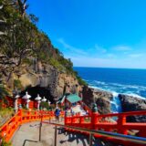
【Cape Sata Park Misaki Shrine】
![DSC 2773 1024x768 - Cape Sata Park (Misaki Shrine) [Kagoshima]](https://japan-shrine.info/wp-content/uploads/DSC_2773-1024x768.jpg "Cape Sata Park (Misaki Shrine) [Kagoshima]")
Halfway along the boardwalk leading to the observatory was a red-roofed shrine. It stands among subtropical trees with cycads growing thickly.
![DSC 2776 1024x768 - Cape Sata Park (Misaki Shrine) [Kagoshima]](https://japan-shrine.info/wp-content/uploads/DSC_2776-1024x768.jpg "Cape Sata Park (Misaki Shrine) [Kagoshima]")
Misaki Shrine was built in 708. The exact origin of the shrine is unknown, but it is said to have been built in a cave on the steep rock face of Cape Sata. Today, the shrine is popular as a god of marriage.
【Sado Point Park Observation Deck】
![DSC 2766 1024x768 - Cape Sata Park (Misaki Shrine) [Kagoshima]](https://japan-shrine.info/wp-content/uploads/DSC_2766-1024x768.jpg "Cape Sata Park (Misaki Shrine) [Kagoshima]")
A further 800-meter walk along the undulating promenade leads to an observatory with a magnificent panoramic view of the Pacific Ocean and the East China Sea.
![DSC 2770 1024x768 - Cape Sata Park (Misaki Shrine) [Kagoshima]](https://japan-shrine.info/wp-content/uploads/DSC_2770-1024x768.jpg "Cape Sata Park (Misaki Shrine) [Kagoshima]")
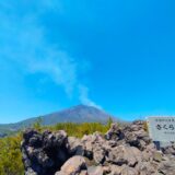
On a clear day, Mt. Kaimondake, a 924-meter-high volcano also known as “Satsuma Fuji,” as well as Iwo Jima, Takejima, Tanegashima, and Yaku Jima can be seen.
【Cape Sata Park (Misaki Shrine) Nearby attractions】
Sugawara Shrine (Arahira Tenjin)
![DSC 2736 520x300 - Cape Sata Park (Misaki Shrine) [Kagoshima]](https://japan-shrine.info/wp-content/uploads/DSC_2736-520x300.jpg "Cape Sata Park (Misaki Shrine) [Kagoshima]")
【Cape Sata Park (Misaki Shrine) Access】
Manager’s Comments
Here we are at last, the southernmost point of the mainland! Next to the observatory, there is an information center where souvenirs and soft-serve ice cream are sold. Here, you can get a certificate for reaching the southernmost point of the Japanese mainland. The weather was fine, so we enjoyed the great view and thought to ourselves, “We have finally come this far!
952 Arimura-cho, Kagoshima City, Kagoshima Prefecture, 891-1545, Japan
※Free parking available.
![cf344e0c83cf22fe2bf6d2771ec92c4b - Cape Sata Park (Misaki Shrine) [Kagoshima]](https://japan-shrine.info/wp-content/uploads/sng/cf344e0c83cf22fe2bf6d2771ec92c4b.jpeg "Cape Sata Park (Misaki Shrine) [Kagoshima]")
![DSC 2735 150x150 - Cape Sata Park (Misaki Shrine) [Kagoshima]](https://japan-shrine.info/wp-content/uploads/DSC_2735-150x150.jpg "Cape Sata Park (Misaki Shrine) [Kagoshima]")
![DSC 2736 150x150 - Cape Sata Park (Misaki Shrine) [Kagoshima]](https://japan-shrine.info/wp-content/uploads/DSC_2736-150x150.jpg "Cape Sata Park (Misaki Shrine) [Kagoshima]")
![DSC 2688 150x150 - Cape Sata Park (Misaki Shrine) [Kagoshima]](https://japan-shrine.info/wp-content/uploads/DSC_2688-150x150.jpg "Cape Sata Park (Misaki Shrine) [Kagoshima]")
![DSC 2711 150x150 - Cape Sata Park (Misaki Shrine) [Kagoshima]](https://japan-shrine.info/wp-content/uploads/DSC_2711-150x150.jpg "Cape Sata Park (Misaki Shrine) [Kagoshima]")